The Route to Climb the Volcano on Tristan da Cunha

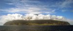
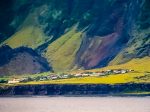
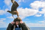
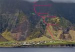
Having failed to preplan on my first visit to Tristan da Cunha, the second time, I asked the captain to radio ahead. So, when we arrived, my climb was already approved by the governor. Two locals and I climbed up the walls and over the clouds to reach the summit of Tristan Da Cunha. March 18, 2006 - Today was a great day, as I was able to achieve a long-standing wish to climb the highest peak on Tristan Da Cunha. I was awoken at 6a and shortly afterwards told that the guides were ready to go. I was surprised, because last night I was told that they would not arrive till 630a or 7a, or possibly later. We were off, me without breakfast or any drink, at 635a. I was going on a ten-hour round trip up the mountain. We walked along the road and turned left towards the hills, roughly where I was last night. We went up the grassland and then up the steep grass slope which narrowed to a wedge. This met the steeper yet rock and grass slope. We traversed left across a small section with fixed rope. I was told to hold the rope below me, on the left side. I presumed this was in case of a slip, I would bump into the rope. I was carrying a full liter of water, my camera with the extra 35-350mm lens, my video camera, waterproofs, trail mix, and sundry other items. I found out later that I had only brought one video tape and so had to conserve. Jerry carried my small thermo of tea and Wayne carried a small box of sandwiches that Rose had fixed. Between them they had two sodas for me as well. I was probably carrying about 25 pounds of gear, includiing a tripod. After 45 minutes, I said I would like to get some tea. Jerry told me to go up a bit further. We sat in steep grass. I had some lukewarm tea and some trail mix. We continued upwards. The trail often was only about a foot wide, hugging the steep slope, mostly with grassland on the right and left. Sometimes the left side was exposed, and mostly in these areas, there were fixed ropes. How strong these were is a matter of debate. All tolled there were about five or six of these roped sections. At one point, I was told that I should be careful as there was a cliff off to the left. In one or two places a good fall, meaning that you would roll a bit or not be able to catch yourself, would have been fatal. Sometimes the trail went up and over a ridge in a way that visually it was not clear how one would proceed past the line of sight. Jerry had advised me that I should do my photography now, as there was a chance that on descent it would be cloudy. Several times I turned and took photos of Edinburgh, appearing straight down below us as the sun cast its first morning light upon it. We passed the central cliff and now entered a new gully, a continuation of the same gulch but marginally more protected from sheer falls. The trail hugged steep grass slopes. I told them I wanted to video them hiking and asked them to stop. I retrieved my video camera and shot them going up. Even though the grassland was steep, there were holes worn the entire way up just big enough for a foot to rest. Without these, it would have been immensely more difficult. Again, there were moments when it was not clear how the trail could continue, but it always did. I was told to look up, and I saw that clouds had disappeared and the Peak was visible. I stopped again to photograph it. We finally arrived at The Base, which essentially is the 2000 foot-high skirt that rims the upper island and falls rather dramatiically to the sea around the island. We stopped for refreshment. One hour forty five minutes had elapsed. We continued on after a rest through gradually sloping open country with two-foot high tree ferns all about us. We crossed a rickety low fence. Now began the grassland. At first this rose gently and then became steeper. We climbed a graceful ridge that forged its narrow finger upward and rolled off on each side. I noticed at one point on the left was a rather dramatic fall-away to a ravine, perhaps five hundred feet below. We had some refreshments. Jerry estimated that we should arrive on top in about two and a half hours, by about 1030a or 11a. Wild sheep grazed on a distant ridge. Some were white and some were black. I set up my tripod and tried to photograph them, but we were two distant. I deviated from our path a bit to get closer, and tried again to photograph them. Even though we were 1/3 km away, the sheep were very wary of us. We continued up and slightly to the left, where we traversed a small section of volcanic debris, where again, I stopped to video my guides' progress. Past this section, we hit a new gully with some larger stationary rocks and a floor of loose rock and sand patched with carpet of grass. We worked our way up. Mist moved in and out of my line of sight, obscuring my view but enhancing the atmosphere, giving it a touch of mystery. During this entire ascent I continually weighed the desire to film or photograph against the need to proceed up the mountain, lest the weather change and the guides, God forbid, say that we must abandon the climb. I checked my watch. I had been so long filming that four hours had now elapsed. I sensed the need to concentrate on reaching the summit. We came out above the mists to a new geography, one marked almost exclusively by volcanic debris. Wayne called on his radio to Connie, the police chief, saying that we were ten of fifteen minutes from the top. Based on the fact they told me the summit was just beyond the rock buttress, a landmark visible from the gulch, his estimate seemed understated. Volcanic debris is always a bit frustrating to ascend, since one's feet have a tendency to slide back down a few inches with every step. We reached the summit in about a half an hour. When we arrived, Jerry said, "This is The Peak." I looked upward. "What about that?" "That's Queen Mary's Peak. Go on ahead if you like. But stay on...." I understood him to mean that I should stay off of the south edge. When Jerry and Wayne spoke, it was often difficult to understand them. I had a snack and a drink, then took off my shorts, which had been falling off of me the whole way up (since I had no belt) and changed into my climbing tights. The Peak proper is about twenty meters higher than the lake, which lies in the bottom of the crater. The rim continues gradually up about 120 meters to Queen Mary's peak. As I came to a raised section of rock, I went on the southern side, out of the view of the guides. The skies were clear for 1000 meters down the hill side. A coupld of dramatic spires of rock shot straight up, sloping downward in jagged edges. Far below, I could see two lakes. I came up to just below the summit and set up my tripod and video camera. I filmed myself walking the last few meters. Then an idea hit me: to do the Saint Kildar pose as Dick McConnell had described to me. He told me that on the island of Saint Kildar, now uninhabited, it was tradition for men to prove their manhood by going to a vertical cliff, putting half a foot off the edge, then holding their other foot with their arm, their leg perched out over the cliff. I assumed this pose for the camera. I set up my tripod at the summit and used the delay mechanism to take photos of the same pose. When I reviewed it, it looked so ridiculous, it made me laugh. I walked down to the lake and took a sip of the water, as the townspeople had told me you could drink from it, and I had to test to see that it was true. Jerry, Wayne and I descended down the volcanic rubble. I questioned it when they turned back right again, but they assured me this was the route we took up. We went down the gully of rock and grass. I asked Jerry to take a photograph of me. He teased, "What do you think you are, Elvis?" (I found out later that this small island has its own Elvis Presley impersonator.) We did a detour to the left , going down grassland with some rock and gravel. Sometimes they stopped and talked amongst themselves, deciding which way to go. We went right, then left, then down. Jerry told me to be careful in the grassland, for there were occasionally invisible holes. He said that once his foot got caught in one and he felt a terrible pain. He had torn many ligaments and was barely able to walk. Jerry mentioned that the grass was high, but it used to be much shorter because there were more sheep. I asked why that was. He said that there are less sheep, he figured, because they don't shear them in the summer, and they get too hot. I asked him if the lobster factory was the cause of them not shearing the sheep. He said that was true. Now, he said, the good days, when they used to shear thesheep, are fishing days. He said they had a quota to fill. We descened the fingered ridge again. The guides walked down as I took a photograph of them. The ridge fell off into mists on the right and left. When the mist cleared a bit, I noticed just how deep and wide the chasm to my right was. The trail went within a few feet of its edge. Eventually, we came down the fern grove. The guides lay against their rucksacks as I came up. They pointed to an albatross in the ferns. It was a chick, but large as an adult. I got out my tripod, but Jerry questioned me as to why I was doing that. He said I could walk right up to it, that it could not fly. I took my full of photograhs of this lovely bird. It was all downy white. Even though I had taken many photographs in the Falklands of similar chicks, this one seemed special, there, alone, on the great mountain, waiting for its parents to return with food. Jerry, Wayne and I continued to the edge of the escarpment. Jerry suggested that I put my tripod into my pack to avoid it catching the earth and sending me head over heels. I heeded his warning. Jerry went off down the edge, seemingly off into thin air. Wayne and I followed. I slid on my butt part of the way, it being much easier than trying to maintain my balance standing while descending. We came past a rat trap. I had told them I had a little film left on my video that I wanted to use on a steep section. I found out that this place is known as Hottentot Gulch. It is not the normal route. We came to a good view of Edinburgh. In the afternoon sun, the dramatic relief of the ravines was more apparent. I videoed my last seconds of film. My camera was full, so I did not take a still photograph, but furhter down, I erased an image to make way for another and snapped my last photograph of the day. We tramped down the last segments, crossing the fixed rope sections. It was clear from these heights that my ship, the Alexey Maryshev, was still not in the harbor (having gone to Inaccessible and Nightengale Islands). Finally we descended the steep grasslands. Sheep ran away. Wayne scooted down the mountain with alacrity, being confident of his feet. Both men showed great ease on the mountain. I, on the other hand, felt relatively clumsy. The entire way up and most of the way down, I had one or two cameras hanging over my neck. It consumed considerable energy to keep them out of harms way. Also, I wore running shoes. By the end of the day, my feet, which had been often wet, were shot. We came to the road and to Rose and Albert's house. I asked them if I could ask them questions on the video about the changes on the island, the long boats and the like, the things we had diiscussed. They said I should ask Albert, that he would be happy to do it. We said goodbye. Even though all I wanted was to have a tea and some break pudding, Rose fixed me an entire lamb meal with the left overs from last night. After I was done, she brought me bread pudding. I ate it as fast as I could so that I could interview Albert, who had agreed to my suggestion. After the first eight minutes of filming Albert, I realized that I had the sound too low. Albert accommodated me going over some of the questions again. He described the old ways of the island, of how the men were the best sailors in the world, he reckoned, and, for the finale, I asked him to recount the story of when his long boat was attacked by a great white shark. He said that when he shot it for the last time, he was so close that the shark's blood soaked his shirt! I thanked Rose and Albert profusely. Staying with them was an experience in itself. I went down to the museum and bought some souvenirs for the family. At the harbor, I met the Administrator. We had a chat with David and Dolf. I had to borrow money to pay the guides. Jan agreed to let me go back on board the ship to get the Ibuprofen I had promised Albert. His leg needs an operation and causes him a lot of pain. When I got on the ship, it seemed that everyone was curious about my climb and whether I had been successful. They were very kind, inquiring how it had gone.
- Nation: St. Helena
- ISO Province: Saint Helena, Tristan Da Cunha
- TCC Country: Tristan Da Cunha
- Place: Tristan da Cunha
- Year: 2016
- File name:
- Categories: Uncategorized
- Photo upload size: 4151×2900
- Photo display size:
More photos from Saint Helena, Tristan Da Cunha
- UK, Saint Helena, Tristan Da Cunha, View From Ocea…
- UK, Saint Helena, Tristan Da Cunha, Village, 2002 …
- Gough Is, Skua Biting Olav's Head, 2006 - Olav, a …
- Having failed to preplan on my first visit to Tris…