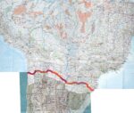
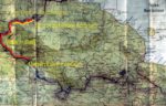
Papua New Guinea, Map of Trek, 1983

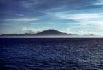
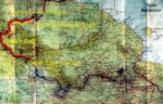
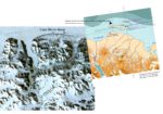
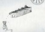
Papua New Guinea, Map of Trek, 1983 - The loop at the bottom center shows the hike to Lake Kutubu. To the left center, there is a hash mark, indicating Lake Kopiago. From there I traveled twenty-nine days on foot to Ok Esai, a tributary to the Frieda River. This is shown on the upper left by a another hash mark. From there, I rode on a bush raft made of logs and tied together with jungle vine (canta), down the Frieda River to the Sepik, and down the Sepik to the village of Ambunti, another ten days. The straight line at the top left of the map going north indicates the road to Wewak.
- Nation: Papua New Guinea
- ISO Province:
- TCC Country: Papua New Guinea
- Place: New Guinea Highlands
- Year: 1983
- File name: PNG,MapOfTrek,1983.jpg
- Categories: New to Show, Tribal People
- Photo upload size: 4800×3085
- Photo display size:
More photos from
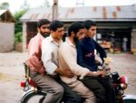
- Iran, Four Guys on Motorbike, 1984 - On my journe…
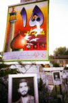
- Iran, Posters of Martyrs, 1984 - In 1984, Iran w…
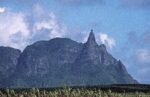
- Mauritius, Rock on Peak, 2002 - I was incredulous …
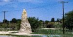
- Namibia, Termite Mound, 2000 - In Africa there a…
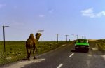
- Turkey, Camel Along Road, 1984 - For me as a Wes…
- Uganda, Elephant Sign, 1984 - I have only seen o…
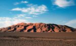
- Algeria, Sand Dunes, 1988 - I had heard of large s…

- Congo Zaire, Baboon On Riverboat, 1984 - I took t…

- Indonesia, Pulsating Rock Yellow, Pink, Red, Viole…
- Kazakhstan, Horse Rider, 1998 - On the way from St…
- Kazakhstan, Mausoleum City, 1998 - On the way acro…
- Kazakhstan, Sunset, 1998 - We camped out most nigh…
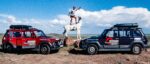
- Lesotho, Land Rover At River, 2000 - I drove nearl…
- Lesotho, Plant, 2001 - I thought this plant along …
- Montenegro, Farm House, 2003 - I drove by myself f…
- Morocco, Morocco Across The Strait of Gibraltar, L…
- Papua New Guinea, Bamboo And Pandanus, 1983 - The …
- Papua New Guinea, Huli Feathers 2, 1983 - The Huli…
- Papua New Guinea, Jeff Shea With Huli Big Man, 198…
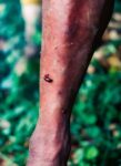
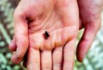
- Papua New Guinea, Leech On Leg, 1983 - This photog…
- Papua New Guinea, Map of Trek, 1983 - The loop at …
- Papua New Guinea, Tree Kangaroo, 1983 - Among the …
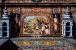
- Portugal, Tile Work, 1988 - I admired the tile wo…
- Solomon Islands, Tiny Frog, 1983 - I was amazed by…
- Somalia, Mogadishu Airstrip, Dallo Airliner, 2002 …

- Tanzania, Jeff Shea On Bus, 1984 - Gabrielle and I…
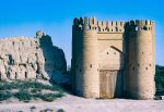
- Uzbekistan, Ancient Gate, 2002 - This ancient gate…
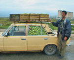
- Azerbaijan, Apples In Car, 2000 - This enterprisi…
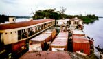
- Congo Zaire, Barge Hits Land, 1984 - The river boa…
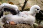
- Falkland Is, Black-browed Albatross Young, 2006 - …
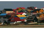
- Falkland Is, Houses, 2006 - I woke late and found …
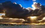
- Falkland Is, Port Stanley, 2006 - On the way back …
- Iraq, Ancient Costumes, 2000 - These costumes on d…
- Niger, Niamey, Clothes Washer On Niger River, 1988…
- Pakistan, Forty-Eight Hour Bus Ride From Quetta To…
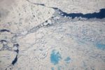
- Greenland, Warming Island, off coast of Liverpool …
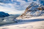
- Greenland, Warming Island, off coast of Liverpool …
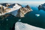
- Greenland, Warming Island, off coast of Liverpool …
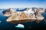
- Greenland, Warming Island, off coast of Liverpool …
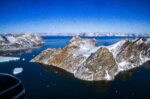
- Greenland, Warming Island, off coast of Liverpool …

- My diary entry of the day we visited the Tree of L…

- Japan, Shoji, 1994 - This photograph was taken in …
- Slovenia, Scrap Metal, 2006 - There was a pile of …
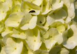
- Slovenia, Insect In Flowers, 2006 - A small bug ro…
- Japanese Inn, 1994, Japan…
- Romania, Farm Girl Sitting On Wagon, 1997 - On my …
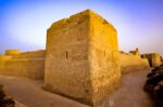
- Qatar, Old Fort, 2000 - …
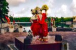
- Mauritius, God, 2003 - This statue is in a temple …
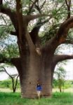
- Botswana, Baobab, 2001 - The Baobab tree is one of…
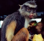
- Congo Zaire, Monkey on Riverboat, 1984 - This beau…
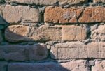
- Iraq, Ancient Bricks, 2002 - The ancient sites in …
- Kazakhstan, Jeff Shea On Tibet 98 Expedition, 1998…
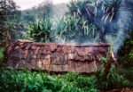
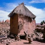
- Papua New Guinea, Hut, 1983 - The roof of this low…
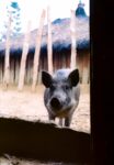
- Papua New Guinea, Pik, 1983 - The pig is a very va…
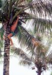
- Solomon Islands, Jeff Shea Getting Coconuts, 1983 …
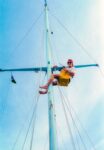
- Solomon Islands, Jeff Shea In The Bosun Chair, 198…
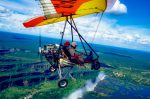
- Zambia, Microlite, 2000 - Taking a microlite over …
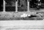
- Mexico, Sleeping On The Stairs, 1993 - It seemed s…
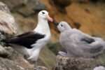
- Falkland Is, Black-browed Albatross Feeding Young,…

- Iraq, Barf Detergent, 2000 - One of the examples o…
- Iraq, Portrait Of A Girl, 2000 - The young women i…
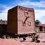
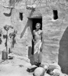
- Mali, Bankas, Dogon Hut 1, 1987 - I came upon thes…
- Mali, Bankas, Dogon Hut 2, 1987 - This is the seco…
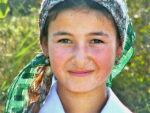
- Mali, Mopti Area, Bozo Girl, 1987 - When I was in …
- Greenland, Warming Island, off coast of Liverpool …
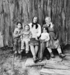
- Romania, Generations, 1997 - A few months before I…

- …
- Slovenia, Old Woman And Fire, 2006 - Lee McLaughli…
- Madagascar, Girl, 2003 - Madagascar was a wonderfu…

- Trinidad, Girls In Rain, 1997 - On one of my many …

- Trinidad, Woman With Stray Eye, 1993 - A woman sit…
- Romania, Young Man In Doorway, 1997 - I walked acr…
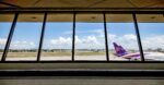
- PH, Manila, Airport, 2008, IMG_1670 - A photograph…
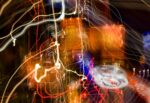
- PH, Manila Light Painting 1, 2008, IMG_2277 - A st…

- PH, Manila Light Painting 2, 2008, IMG_2275 - Real…

- …
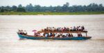
- Myanmar, Unknown Prov, Beans…
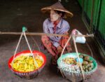
- Myanmar, Unknown Prov, Bicycle Vendor Scene…
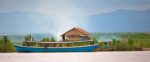
- Myanmar, Unknown Prov, Boat Detail…
- Myanmar, Unknown Prov, Boat Detail…
- Myanmar, Unknown Prov, Boat Detail…
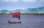
- Myanmar, Unknown Prov, Boat River…
- Myanmar, Unknown Prov, Boat River…
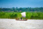
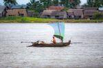
- Myanmar, Unknown Prov, Boat Scene…
- Myanmar, Unknown Prov, Boat Scene…
- Myanmar, Unknown Prov, Boat Scene…
- Myanmar, Unknown Prov, Boat Scene…
- Myanmar, Unknown Prov, Boat Scene…
- Myanmar, Unknown Prov, Boat…
- Myanmar, Unknown Prov, Boats River…
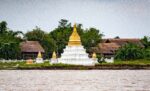
- Myanmar, Unknown Prov, Temple Detail…
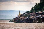
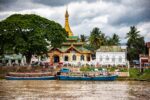
- Myanmar, Unknown Prov, Temple Near River…
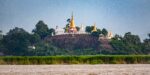
- Myanmar, Unknown Prov, Temple Near River…
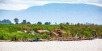
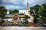
- Myanmar, Unknown Prov, Temple Village Near River…
- Myanmar, Unknown Prov, Temple Village Near River…
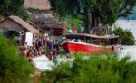
- Myanmar, Unknown Prov, Village People River Boats…
- Myanmar, Unknown Prov, Water Scene…
- Myanmar, Unknown Prov, Water Scene…
- Myanmar, Unknown Prov, Water Scene…
- Myanmar, Unknown Prov, Water Scene…
- Myanmar, Unknown Prov, Water Scene…
- Myanmar, Unknown Prov, Water Scene…
- Myanmar, Unknown Prov, Water Scene…
- Myanmar, Unknown Prov, Water Scene…

- Myanmar, Unknown Prov, Water Scene…
- Myanmar, Unknown Prov, Water Scene…
- Myanmar, Unknown Prov, Water Scene…
- Myanmar, Unknown Prov, Ayeyarwaddy River…
- Myanmar, Unknown Prov, Ayeyarwaddy River…
- Myanmar, Unknown Prov, Boat Vendor…
- Myanmar, Unknown Prov, Packed Boat…
- Myanmar, Unknown Prov, Boat -…
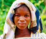
- Zimbabwe, Unknown Prov, Portrait Of Girl…
- …
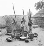
- Three Women Pounding Millet, 1987 Ivory Coast - 6…

- Lila…
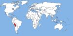
- World Map with the Altiplano shown in red Chile-Pe…
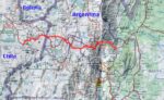
- Map of walk showing route from Socaire to Tilcara …
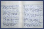
- Original Journal - “This is the last day...”…
- Original Journal - “If you should see...”…
- Original Journal - “Have a lot going for them...…

- Novita on Sun Baked Tiles, 1999 Anguilla - 8x10 fi…
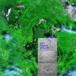
- A Composite of a Satellite Image and Venezuelan To…
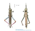
- Bactrophora Dominans, as collected in 2014. I col…
- Telly (José Luis Rodríguez Castillo) first point…
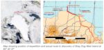
- Map of Previously Unmapped Land-like Features Nort…
- The Discovery of Stray Dog West, one of the World�…
- Sea Ice, 2007 Arctic Ocean…
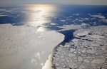
- Melting Sea Ice, 2007 Arctic Ocean For the ice t…
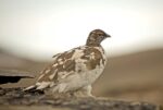
- Rock Ptarmigan [Lagopus mutus], 2007 North Greenla…
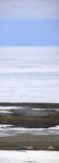
- Base Camp with Coast and Sea Ice, 2007 North Gree…
- Map of Northeast Portion of New Guinea My 39-day …
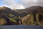
- Strickland Gorge, Oksapmin Side, 1983 Papua New G…
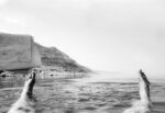
- Writing Love Letter to Judith While Floating In De…
- Gough Island, 2006 South Atlantic, Gough Island…
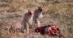
- Cheetahs Feeding on Wildebeest, 1984 Tanzania, Ngo…

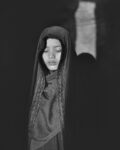
- Behind the Veil, 1999 8x10 film…
- Muslim Girl in Subdued Light, 2000 Saudi Arabia - …
- Sapa Girl, 2008 Vietnam, Sapa - 8x10 film…
- The Alchemist, circa 1973 Jeff Shea - A drawing i…
- Hewa Hat, 1983 I made a crude sketch of the Hewa …
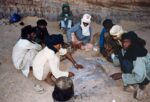
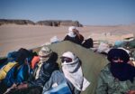
- Cooking Bread in the Sand – One Algeria, Sahara…
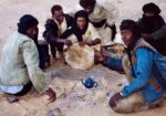
- Cooking Bread in the Sand – Two Algeria, Sahara…
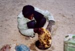
- Cooking Bread in the Sand – Three Algeria, Sahar…
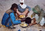
- Cooking Bread In The Sand – Four Algeria, Sahar…
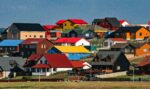
- Port Stanley Houses, 2006 Falkland Islands South A…
- Composite of Soaps that Landed Stuck on their Side…

- Venus, 2013…
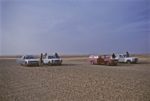
- Cars Being Brought from Europe to Niger for Sale, …
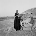
- Touareg Woman with Children, 1987 Mali, Mopti area…
- Bozo Girl with Braided Hair, 1987 Mali, Mopti area…
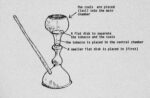
- Rajasthani Water Pipe, 1984 Illustration of Rajas…
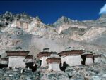
- Convent near Rongbuk Monastery, 1995 Tibet, near R…
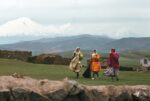
- Mount Ararat and Three Kurdish Women, 1984 Turkey …
- Riding on the Top of a Truck Hauling Dates to Nige…
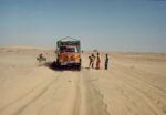
- The Truck Gets Stuck in the Sand, 1988 Algeria, S…

- In the Mirror, 2011…